Recently, a massive undersea earthquake initially recorded as magnitude 8.7 and later revised upward to 8.8, struck off the eastern coast of Russia’s Kamchatka Peninsula. The quake struck at a shallow depth around 18–19 km near Petropavlovsk‑Kamchatsky, greatly amplifying the potential for tsunami generation.
It was described by regional officials as the strongest to hit Kamchatka in decades, and among the top six strongest earthquakes ever recorded . With such magnitude and shallow epicenter, tsunami alerts were triggered across the northern Pacific rim.
Tsunami Impact in Russia’s Far East
In Severo‑Kurilsk, located on Paramushir Island in the Kurils, residents were struck by waves up to 4 meters high. Flooding damaged infrastructure including schools, and authorities declared a state of emergency. Though injuries reported were largely minor, the town experienced considerable disruption as residents evacuated to higher ground .
Russian regional leadership emphasized constant vigilance, warning that multiple tsunami waves may follow the initial surge and that the threat could persist for several hours.
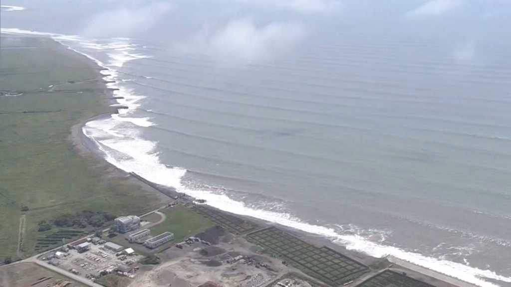
Japan
Japan’s Meteorological Agency swiftly issued evacuation orders for nearly one million residents in coastal prefectures, particularly Hokkaido and parts of Fukushima, Kanagawa, and Miyagi.
In Hokkaido, a small tsunami wave of approximately 30–40 cm was recorded, even as precautionary evacuations continued across the region. Authorities warned that subsequent waves could be higher and remained vigilant into the evening hours.
Cities such as Fujisawa in Kanagawa Prefecture cordoned off beaches and evacuations were initiated via sirens and public announcements. Many residents moved swiftly inland or reached designated high-ground shelters, following established tsunami safety drills.
Officials reiterated that tsunamis can consist of multiple waves arriving over extended periods, urging continued avoidance of shorelines even after the first wave subsided.
The United States, Hawaii, Canada
Hawaiian authorities activated all emergency operations centers, issuing tsunami warnings with waves expected in the 1–3 meter range. Governor Josh Green urged immediate evacuation of coastal zones across all islands, citing risks of flooding and powerful currents.
Initially, the National Tsunami Warning Center issued a tsunami watch for the entire US West Coast, including California, Oregon, Washington, Alaska, and British Columbia. Within hours, key areas were upgraded to tsunami advisories or even warnings, especially along Northern California’s coastline from Cape Mendocino northward.
Local authorities in Monterey County issued evacuation warnings for people aboard boats and in harbor slips. Although widespread inundation was not expected, strong currents posed danger to structures and vessels.
Authorities in British Columbia issued tsunami advisories in coordination with US agencies, urging the public to stay out of harm’s way along beaches, harbors, and coastal waters.
The Wider Pacific
The Pacific Tsunami Warning Center (PTWC) projected potential wave heights of 1–3 meters across diverse coastlines including Chile, Peru, Ecuador, Solomon Islands, Taiwan, Indonesia, New Zealand, Tonga, and French Polynesia—with some regions expecting up to 3–4 meters depending on local seabed bathymetry and coastal shape.
Ecuador ordered evacuations in the Galápagos, expecting waves up to 1.4 meters. Peru and Chile issued alerts Mexico monitored coastal zones. Authorities in New Zealand, Philippines, and Australia issued warnings and urged people to avoid low-lying coastal areas.
Why the Tsunami Formed
The quake’s high magnitude and shallow depth near a subduction zone meant the ocean floor was abruptly displaced, generating tsunami waves. Similar seismic events—especially in the Pacific “Ring of Fire”—have historically triggered destructive tsunamis.
Early Warning Systems at Work
Regions under threat relied on high-tech tsunami monitoring networks, including Seismic recording arrays to detect and locate quakes within seconds. DART buoys (Deep-ocean Assessment and Reporting of Tsunamis), which detect pressure changes on the ocean floor and transmit alerts in real time.
National systems like Japan’s Meteorological Agency, PTWC in Hawaii, and INCOIS in India that process data and swiftly issue warnings. Japan’s system is tuned to dispatch tsunami warnings within minutes of strong offshore earthquakes, a system refined following the 2011 Tōhoku disaster.
Safety Measures, Aftershocks, and What Comes Next
Authorities globally emphasized continued caution over the following days, warning that aftershocks—some up to magnitude 7.5 could further disturb the ocean floor and generate additional waves.
Public Safety Protocols
Common advice includes Move to higher elevations immediately when alerted. Stay inland and away from beaches, harbors, and marinas. Avoid maritime activity until the all-clear is given. Monitor local broadcasts, official apps, and government social media channels regularly for updates.
Historical Comparison and Long Term Lessons
Earthquakes of magnitude 8.8 in subduction zones have historically caused major tsunami disasters, the 1952 Kamchatka quake, for instance, produced waves that reached Hawaii and devastated nearby islands.
This event weaker than some historic megathrust quakes, nonetheless showed how even moderate tsunamis can trigger mass evacuations, coastal disruptions, and require global alert coordination. It reaffirms the importance of constant readiness and public awareness in hazard-prone zones.
A Wake‑Up Call for Global Coastal Resilience
Kamchatka earthquake and resulting tsunami warning felt across continents served as a powerful reminder that seismic energy released in one region can propagate thousands of kilometers and disrupt communities far beyond the epicenter.
While some regions like India were unaffected, proactive measures by authorities in Japan, Hawaii, the US West Coast, Russia, and Pacific island nations helped avert major casualties.
Going forward, this event will be studied to refine hazard modeling, improve early warning communications, and enhance public emergency preparedness, especially in an increasingly interconnected and geologically volatile world.